
Page 11 - UmRio Sustainability - Action Plan
P. 11
PROJECT BACKGROUND
PROJECT LOCATION & CONTEXT
Morro do Castro and the city of Niterói in the state of Rio de Janeiro.
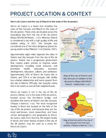
Morro do Castro is a favela that straddles the
cities of São Gonçalo and Niterói in the state of
Rio de Janeiro. These cities are located across the
Guanabara Bay from the city of Rio de Janeiro
(Mapa MICHELIN Niterói -, n.d.). Whereas Niterói
is considered a city with a high quality of life and
relative safety, in 2021, São Gonçalo was
considered one of the most dangerous places for
young adults to live (“Niterói,” n.d.) (Deister, 2021).
Approximately eight miles separate the cities of
Niterói and São Gonçalo from the city of Rio de
Janeiro. Niterói has a progressive government
that creates public policies to improve urban
development, including social inclusion, and
prioritizes health, education, economic
development, education, culture, and sanitation.
Approximately 25% of Morro do Castro lies in Map of the city of Niterói and
Niterói, and 75% is in São Gonçalo. Still, UmRio São Gonçalo in relation to Rio
has a better relationship and more support from de Janeiro (Mapa MICHELIN
the city of Niterói. Officially, São Gonçalo claims Niterói - ViaMichelin, n.d.)
Morro do Castro as one of their neighborhoods.
Morro do Castro is not in the city of Rio de
Janeiro. Rather, it is in the state of Rio de Janeiro,
located across the Rio-Niteroí bridge, and
straddles the towns of Niterói and São Gonçalo
(“Mapas e Bairros,” n.d.). The most recognized
favelas in Brazil are located on the hills of the
city of Rio de Janeiro, and because they are the
most well-known, most researched, and have
similar demographics and geography to Morro
do Castro, data from Rocinha, the largest favela
in Brazil, and other favelas located in the city of Map of districts within the city of
Rio de Janeiro, may be used as a proxy for São Gonçalo from the city’s
Morro do Castro. website. (“Mapas e Bairros,” n.d.)
www.umrio.org Page 6